
8-30-04
We woke early in Springfield, Missouri and had our coffee. We had prepared the bikes the night before and had everything ready for an early start. It was Monday. Ideally we would have liked to have started on Saturday and gained the addition of a weekend of travel, but Paul’s new bike just wasn’t ready. On the Butterfield Coach run delays were to be expected so we were in the right mindset. We knew the Butterfield Creed would see us through. “Remember boys, nothing on God’s green earth must stop the United States Mail.” We were not obligated to a strict time table, anyway. Though our time was limited our main goal was simply to make it to our destination, Fort Bowie, Arizona. Now, the horses were ready and after some tying on strapping in and settling down we were ready, too. Above can be seen our mighty steeds.
 Note the coolest leather jacket ever to grace a would be biker. My lovely wife, Judy, spent time and considerable energy rejuvenating my old bike jacket, an authentic WWII leather flight jacket. She included some heavy mojo magic and iconographic appliqué. I had not ridden a motorcycle for many years. Though I wasn’t a stranger to it, I’d have to say I felt very out of practice.
While we were drinking our coffee, I took a moment to rest on
 my bike and feel the pack placement. Paul snapped this odd picture that is quite eerie and reminded us both of the dead outlaws they stood up after the bank robberies and photographed
Fortunately, it did not portend a disastrous foreshadowing.
We finished our coffee and made ready. Our
 first day was planned. We were to head north to catch the beginning of the Butterfield Overland Mail right where John Butterfield left the train from St. Louis. The mail came over land by rail on the Pacific Railroad along the Missouri River and through Jefferson City and on to the western terminus which at the time was in Tipton, Missouri. A distance of about 160 miles. Our research indicted there was a Stagecoach station in Versailles, Missouri and we also wanted to investigate the possibility that the old mail route went through there on its way to Springfield. We elected to travel by fastest route to Versailles.
Tipton was 140 miles from Springfield and we were acutely aware that we were beginning our 2,000 mile journey ironically by going in the wrong direction. We thought though ,that it was very important to begin at the beginning. The morning rolled out in front of us. The first few miles were filled with an excitement and tension as I allowed my body to remember the feel of a 750. The low sun glared blindingly as we wound our way through city streets and made our way to the interstate. The Yamaha handled like a dream. Better than my old bike and it wasn’t long at highway speeds before it became second nature. It was a dream come true. The complete freedom of the road and a wonderful narrative to pin the adventure on.
Arriving in Versailles we found the Stage Stop marked but the museum was closed on Mondays. So, we made notes and took a picture and went on to Tipton hoping that maybe a local could give us directions.

The Stage stop was in this set of buildings called the Martin House which was of the same period. However, as we discovered it must have been a “star” line that fed over to the Mail Route in Cole Camp.
Versailles marks the beginning of a trail that was established in 1836 to Fayetteville Arkansas. (In Arkansas this was referred to as the Springfield Road.) As it turned out we were to discover that the Butterfield utilizes a portion of this older road picking it up at Cole Camp and generally following it all the way to Fayetteville. Butterfield was, however, known to shortcut routes by building his own roads where he felt the time and expense would be returned by making the route more efficient and insuring the expeditious delivery of the mail.

We arrived in Tipton by noon and had little trouble locating the old part of town. The site of the old train station is now City Hall and the Police Station. In 1858 this area would have been a dusty plaza. The train tracks are visible beyond.
You can see a marker on the lawn. Behind it leaning against the wall was a grand discovery. Apparently, as part of a centennial celebration in 1958 these concrete markers were erected at the stations in Missouri.
Trying to locate them became a delight and an immense help in deciphering the location of the old route. The folks at City Hall were very helpful and we found a book there that proved quite useful though not entirely accurate. “Butterfield Run through the Ozarks” by Phillip Steele.
Here can be seen some period buildings just across from City Hall.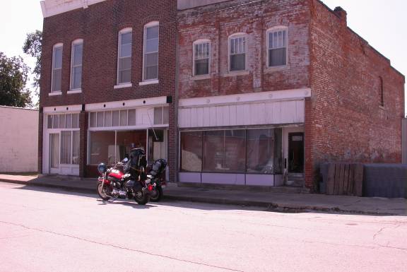 At 6:00 pm on Thursday September 16, 1858 having left St. Louis at 8:00 am the train and the mail arrived in Tipton. The town was only a few months old and had a population of about 200 by then, all of which apparently turned out to meet the train but without much fanfare. It took just 9 minutes to transfer the mail and passengers onto the waiting stage and off they went into the fading evening.
The mail was loaded onto a Concord Coach driven by John Butterfield’s son, John Butterfield Jr. Butterfield was himself a passenger as far as Fort Smith, Arkansas as was the only through passenger on the first Overland Mail run. His name was Waterman L. Ormsby.
Pictured at right, Orsmby was only 23 at the time. He was a reporter on  special assignment for the New York Herald, engaged to send dispatches back to his publisher and inform the interested east coast readers about the progress of this most ambitious endeavor.
It is hard to imagine what it would have been like for Waterman Ormsby as he climbed aboard that first coach in the company of John Butterfield and his son. Butterfield was by all accounts a singular person. He was immaculately dressed with his tight-fitting trousers tucked into high-topped boots, a long yellow linen duster and a flat topped, wide brimmed hat called a “wide awake.”
The coach itself was of the finest quality. A Concord Coach drawn by six horses. The Concord was renown for its superior workmanship. Made in Concord, New Hampshire by the firm of Abbot and Downing at a cost of $1050, the Butterfield coaches were painted either Red or Green with Yellow trim . The unique three inch thick oxen-leather through-braces suspended the coach like a cradle on wheels. Though it provided more comfort for the passengers the innovation was installed to safeguard the horses from jarring injuries. The wheels were fitted with special 4 inch steel bands rather than the customary two inch.

“The commonest model stood 8'6" tall from ground to roof-rail, the rear wheels being 5' across and the front ones 3'10", and left a track 5'6" wide. Each was made exclusively by hand, over about three weeks, by a team of three or four men working together. Its top, floor, and ends were fashioned of solid oak, the graceful side panels of countless layers of paper-thin basswood or light pine steamed and curved to fit stout ash frames, painstakingly laminated, dried, and coated with tough, glass-smooth varnish.
The planks were hewn of clearest pine and birch, and the metal (including the axles) all steel except for the brass trimmings. The wheel hubs were of specially seasoned elm, the rims hardest hickory, and the spokes hand-hewn ash or tough oak. The brake lever was four inches wide, so the driver's foot could find it easily and use it like a third hand. A minimum of metal joinery was used, and what there was best Norwegian iron. Eight steer hides were required for the boots and thorough braces of a single coach. Buyers chose the color scheme, which ordinarily involved a very fanciful combination of a deep red (sometimes yellow) background trimmed with red, gold, vermilion, black, and yellow, with floral and vine designs on the body panels, often portraits (usually of beautiful women, political figures, the American eagle, or other characters of fiction or mythology) on the doors, or perhaps scrolls and landscapes.” Butterfield’s coaches were emblazoned with the words “Overland Mail Company”.
Orsmby’s first person account of his adventure as the only through passenger on the first overland run became the impetus for our journey.  Paul had purchased a copy of Ormsby’s book at Fort Bowie, Arizona on one of his many western tours and proceeded to mount his praises for this amazing enterprise until I too became interested. After he told me about it I kept seeing the name, “Butterfield” on area roads shopping malls or even retirement homes. This inspired me to ask the simple question, “Where exactly did this mail route go?” We seemed to have encountered it in nearly every state during our wanderings out west. References to it would pop up in the most unlikely places. At first it was enough to know that it actually started in Tipton and went through Springfield on its way to Fort Smith and eventually San Francisco. The Overland Mail was the inspiration for such glorious cowboy movies as John Wayne’s “Stagecoach.” I had always associated stagecoaches with the Wild West, but what did Missouri have to do with stagecoaches? What did these references to the Butterfield in Springdale, Arkansas mean? It was quite a revelation to discover that it all had a beginning in Tipton, Missouri. The original “stagecoach” started here! It went right through our backyards. Suddenly, the history of the old west was alive and breathing right on the drab highways outside our door. It came through here? Exactly where? And so with the internet as a tool and google as my guide I set out to put history back into the concrete, asphalt and crowded cities of my immediate surroundings.
I had always been interested in knowing about the early roads of a place. The first roads often followed the traces and pathways of the Native Americans. They in turn marked the movements of the game that sustained them and the cultural pipelines of trade and commerce among the earliest inhabitants. It gives a place meaning to connect it to the past and to the people that first chose to live there. It helps to understand what brought them there, what kept them there and how a community forms and grows and survives or as can be seen along the Old Butterfield Trail, how changes can bring about an abrupt end to the raucous business of keeping a town alive.
And there we stood in just such a place. Once, Tipton was known through out the country, made famous as the Western terminus of a mighty railroad with aspirations of going all the way to the Pacific ocean. But more significantly, it was chosen as the Eastern terminus for the first great transcontinental mail system in this vast country. The genesis of a free flowing stream of communication that would for the first time connect the East coast with the West. The Information Highway of its day.

And here is the main street of Tipton today. A ghost of the past, hobbed together with small modern buildings and empty of the people and pressures that brought it into being. In 1858 it was the edge of civilization and the mail left from here into the wilderness beyond.
In late 2006 I discovered a self-published 65 page booklet entitled Chasing the Butterfield Overland Mail. (A Road Guide following the old stage route over today’s roads across Missouri and Arkansas). This delightful book by Donald Mincke is a thorough and entertaining exposition of his motoring adventures along the route. It is equiped with maps and detailed "on the road" guidlines for following the route of the Overland mail through Missouri and Arkansas. I sure wish I would have had it in my early research it would have saved me months of head scratching. The link at right will take you to a place you can purchase it. I intend to use it to find some of my the more elusive stations that by necessity we had to pass up on the first trip.
Mr. Mincke shows some of these same buildings on the Main Street of Tipton and identifies the location of the station as occupying the corner where you see the gray building on the left of the picture above.
The first stop for the Concord Coach carrying John Butterfield and the mail was Schakleford’s Station. This was the first of over 200 such stations placed along the way. Located to provide fresh horses and make repairs they also served as post offices for the mail and way stations for feeding the livestock, drivers and the intrepid traveler. Initially my information kept sending me South 7 miles. This is why I was convinced originally that the stage went through Versailles but just as we were getting ready to go I found this reference: “This locality is called Syracuse and is principally owned by T.R. Brayton and Mr. Schakleford, who have done much to establish the route through this section.” Syracuse is a small town on the map about 6.5 miles west of Tipton and on the rail line. Of course, it would make a lot of sense that the mail route would follow the soon to be extended rail route and take advantage of ongoing improvements that were sure to precede the rail line. At left is a picture of John Butterfield
See Map
We traveled Highway 50 west which parallels the railroad bed. Traveling 60 miles an hour we were in Syracuse in no time. Quite different I would think than how it was for Ormsby yet he remarked that, “we seemed hardly to have become comfortably seated in the coach before our attention was attracted to the illumination of our destination.” Syracuse was certainly upon us before we knew it and completely nondescript as we wove our way through the town. We didn’t have any information where the exact location of the station was and were as yet unaware that it might be marked by one of the Centennial Markers and so concentrated on trying to figure out which road south to take. We decided being in the town of Syracuse was close enough to Shackleford’s Station. I returned later and made some inquiries on Main Street at the Syracuse Gift Depot. The gentleman there, Harold Nicks, directed me down D road and told me to look just east of the School House. Wow! Though the station was destroyed by fire in 1861, one of the original structures, which housed passengers, still stands though it has been added onto over the years.
While taking a picture of it I visited with a member of the family that lives across the street. Wished I would have gotten his picture. His name was Allen Stahl. His house is on High Street directly across from the two story white structure near the School. His family has been taking care of this structure for three generations. He seemed proud of his work with the recently painted structure yet wondered aloud if anyone would just think him crazy. I assured him his work was important in saving an historic building and preserving a valuable link to an amazing story.

There is a concrete marker at: N38° 40.070' W92° 52.568'
The next stop on the line was Mullholland Station. Thirteen miles from Schakleford’s.
I had found a reference on a map to a “Butterfield Road” SW of Florence, Mo. and a Butterfield Stage Stop Convenience store and gas ( no longer listed in business). With this in mind we headed south on D road which is the logical extension of the Old Boonville Road (Hwy 5) coming in from the north. I had read somewhere that the mail route followed the old Boonville road. We angled southwest on JJ which followed the ridge tops towards Florence. There is a parallel road that takes off from D road called Buffalo Rd.
Buffalo eventually becomes Florence Trail (or trace) and might more closely approximate the route. In Florence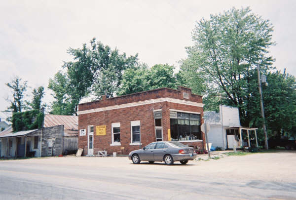 (which I did not get a picture of until later because at this time we were still uncertain if we were anywhere near the mail route)
We met and talked with a local that was very encouraging and he said he thought we were on the right road and that the next station was Mullholland Station and it was near Duane Boafin’s farm. This was the first of many “strangers” which seemed to appear at a moment of indecision in an isolated spot. He was helpful and offered a note of caution as he examined the bikes. “That road gets pretty rough, down there by the creek,” he said matter of fact.
The road SW out of Florence was marked “Butterfield” and we took it but it soon turned to loose gravel. Paul was riding a brand new Yamaha 1100 and was still getting use to it.  It took tremendous courage for him to follow me down that road. In no time, we hit the worst gravel that we were to encounter for the next two thousand miles. Three inch deep freshly laid loose SB #1 over steep terrain. It was everything we could do to keep upright. Unfortunately, about this time Paul got a bug in his helmet and we were so preoccupied with the conditions that we went right by the next Station which is marked with a concrete Centennial Marker. We saw the farm but it didn’t register to stop and take a picture.
Keep in mind this is only station number two and we hadn’t quite figured out what we were looking for. Later, I actually got on the web and located a Duane Baughman who owned the farm. I called him and he even remembered seeing us drive by. He said there is really nothing left of the old station but there is a marker. I went back and found the station later. It is marked with one of the centennial markers and I took pictures. It is located on the east side of the road. Coordinates are: N38° 33.871'W93° 1.324'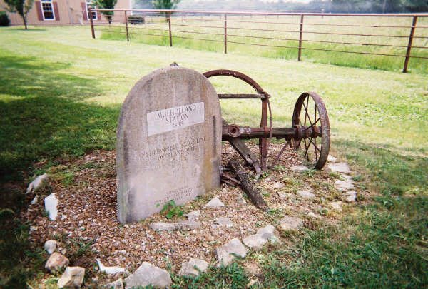
We continued down the road with caution and went through our first low water bridge at Haw Creek. This was covered by about 4 inches of water over mossy concrete but Paul was committed. However, when he saw the first 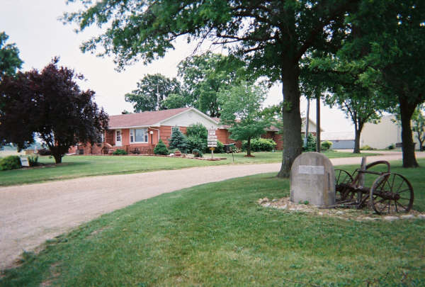 crossroad with pavement he was ready to take a breather so we didn’t try to follow the back roads into Cole Camp. The actual path of the OM is very difficult to discern in this section. Butterfield road ends at KK but there is a road that leads generally in the right direction through a farm SW.
Burns Station was next and was listed as 20 miles from Shackleford’s but south of Cole Camp. Knowing now, exactly where Mullholland was we may assume that it was meant as 20 miles south of Mullholland. We went into Cole Camp for lunch.
I had good evidence that the Butterfield went 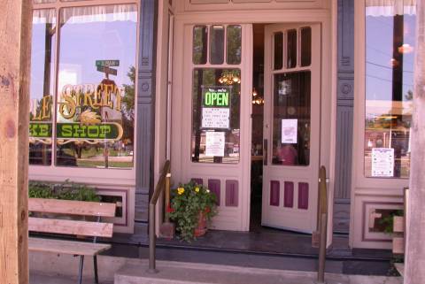 through Cole Camp. The town is said to lie on the junction of four main roads: The Old Military Road which is labeled Butterfield Road as it leaves town, the Duroc Road coming from the “South and a crossing on the Osage River” (which of course also sounds like the Butterfield), and the Jefferson City Road that led east to the Capital. The road east is marked Butterfield but the road north is marked Booneville road. It seems more likely to have been the road coming in from the north as the Old Butterfield was said to follow the Boonville Road. I learned later that the road came in roughly from the northeast but did not correspond to a present day road. The Station list always says “through the outskirts of Cole Camp”. However, there is a road leading out of town to the south called Butterfield which does follow the old road. Cole Camp is a great little town with a charming Historic District. We stopped here for lunch.
Mike, the cook at the Main Street Café in the Historic Bellview Hotel, pointed out that there used to be a Stagecoach station across the street where a new church now stands. Of course this does not appear likely to have been Burn’s Station since it is in the middle of Cole Camp and not 20 miles from Mullholland.
Best guess was that Burn’s Station was south on F. We went that way and at about the 20 mile mark found a Cemetery and an old Red Barn that might have been the location. This was Union-Williams Cemetery which is close to the 16 mile mark Ormsby lists it as 16 miles. On a return trip I was able to contact Bob Owens. He was very knowledgeable and directed me to Burn’s Station.  It is located about 6 miles south of Cole Camp on the west side of the F just after Fordney Road.
The Coordinates are: N38° 23.617' W93° 15.767'.
See Map
We continued on CR NE 71 which became CR SW 291 at the junction H. 291 was marked as “The Butterfield” but brother Paul was feeling the need of a little blacktop so we went West to 65 and then south.

Our next Station was at Warsaw. Warsaw is on the Osage River arm of the Lake of the Ozarks and east of the Truman Reservoir so, much of the surrounding area is inundated and this changed the roads considerably.
We found a Centennial Marker on the square and some interesting pictures in the Title company located there. Approximate coordinates are: N38° 14.585' W93° 22.907' We also had a little bikers convention there, well at least I did . Paul and I got separated for a bit as we went around the square. Fortunately, it was a good reminder of how much trouble that could cause and we avoided it from then on.

To the right is an historic photo of the building that was the stop. (no date)
Below as it looks today:
 and as the Neuman Hotel circa 1858
The first Butterfield left Warsaw under cover of darkness and had to be led across the mud flats by a horse with a rider carrying a lantern. After Warsaw the Butterfield crossed the Pomme de Terre on a covered bridge near Fairfield (sometimes called Fairchild) on its way towards Bailey’s Station. We found a picture of this bridge at the Title Company.
Left is the bridge after the covered part was removed.


No one at the Title Company knew exactly where Fairfield Mill was but they speculated it was inundated by Truman Reservoir. This was corrected when I spoke to Jim Drake at the title company in 2007.K road coming up from the lake to Hwy 83 is the likely road. Fairfield is shown on the topo map at the end of K where it goes into the lake. There is a Pomme de Terre Hall listed there too. Check for history of Bailey’s there. No location has been determined for Bailey’s Station but it is listed as 11 miles south of Warsaw. This places it approximately near the junction of K and Hwy 83.

My May 2007 trip to Bolivar yielded this newspaper photo of the Bailey Station and its location is confirmed to have been inundated by the resevoir.
Judy’s Gap or Quincy Station is listed as 10 miles south of Bailey’s . Coordinates: N38° 0.502' W93° 28.345'
The place (Quincy, named for John Quincy Adams) is right on Hwy 83. Before it was surveyed and platted in 1843 it went by the name of "Judy's Gap", because Samuel Judy had set up a blacksmith shop there, and operated it for several years and there was a gap or opening near this point between Hogle's Creek Prairie, and Twenty-five Mile Prairie. We found this Marker commemorating the Butterfield and lamenting some confusion about who actually ran the station. It listed three possibilities: Joseph Montgomery, Lyman Stilz, or William Morgan.
Next Station is Yoast’s Station 16 miles away via Wheatland.
The route was said to go through Wheatland though it looks a bit right angled from Quincy to Wheatland and then on to Elkton. I feel sure the route was more direct to Wheatland than the  present highway. No secondary road exist today.
An 1876 map shows two possible routes from Quincy to Wheatland and then on to Yoast’s. It is possible that they went east to Bledsoe. Because Yoast’s is south west of Elkton it is also possible that Wheatland was bypassed and the road shown going from Quincy to south of Elkton was used.
Wheatland was fun. They have a Pioneer’s Village, which is comprised of many reconstructed log cabins dating from the same period. One is marked as an Overland Mail Stop. But of course, it is not.
“Yoast was southwest of Elkton, 2 1/2 or 3 miles. A few things are still there to mark the place. “Two pear trees and the old cellar can be seen, also some rocks, the last time a preivious researcher was there." There is a graveyard about 2 ½ miles SW of Elkton on CR 143 and one on top the hill at the end of 115.
There is a marker in Elkton. Talk with someone in Elkton to determine where the Yoast’s place was. Elkton is slightly west of the 83 County road H junction. . Elkton is the birthplace of Sally Rand, (Harriet Helen Gould Beck), the famous Fan Dancer.
Paul and I opted not to go looking for this station on that day. Though it seems likely that it can be found because of the specific location given in some references. It seemed like we were close enough and that further research could be done at later time since it was so close to Springfield.
 Again the trip to Bolivar in 2007 led me to this photo of the Yoast's Station and Ben Gravely at the Polk County Genealogy Society was able to very specifically locate the site of the station. N37° 49' 25.59'" W93° 25'50.68" It is at the junction of Highway 83 and CR 136 on the Northwest corner of the intersection.
Yoast Update 2008 Click Here
The Bolivar Station was at Bolivar, Missouri and located in the Franklin Hotel owned by Ahab Bowen. (pictured)  We talked with some nice folks at the Pharmacy and they told us it was located approximately where Bob’s Barber Shop and the Jewelry shop are on the northwest corner of the square. (See correction below) Coordinates N37° 36.896' W93° 24.703' There is a good Genealogy society located on the square as well in the old library. They were closed when we came through but it is likely they would be helpful and might guide us to a picture of the Franklin Hotel and then take a picture of the present site.
 I did return later and got this wonderful photo of the Franklin Hotel. The Franklin burnt down in January of 1887 and the Horton building now occuppies the same location.

Time was getting late as we headed down the highway toward Springfield on our first day of travel. The next Station listed is Smith’s Station run by James H. Smith which is said to be 11 miles from Bolivar near Brighton on highway 13. James H. Smith was the manager. We did not try to locate the exact position. It seems likely that it is off of Hwy 13 on an outer secondary road. Highway 13 is now a divided and improved highway and it is possible that the Brighton road is Hwy 13 going north. Again this is so close to Springfield that finding where this station is was left to a later time.
While at the Polk County Genealogy Society in May 2007 Ben Gravely and his friend Charlie showed me an 1862 map of the county that included ownership names and old roads. With it we were able to locate a parcel labled M. Smith. I remembered from somewhere that it was James H. M. Smith and that his wife's name was Martha. The parcel was right on the old road but did not correspond precisely to where Mincke had marked it. I matched it to my road map for later reference. Highway 13 is divided and seperated so that north and south bound traffic are far apart. I spent a good deal of time going up and down via short cross-over roads several miles apart until I spotted an old gentleman in his front yard.  He said he had no idea wht I was talking about when I mentioned the Butterfield but pointed up the highway and said, "Do you see that little red building? That's a spring house where they used to water the stage horses. There used to be a sign up there." Eureka!
This jewel of a picture has James (seated) his wife (standing) and the whole dang family (including the dog) standing in front of the Stage stop in 1861. I scanned this from Conkling and Conkling Volume 3. How I acquired the gift of this photo is another story which I will post later.
Nine miles later is Evans Station, (Joseph Evans) still on or slightly off (more likely) of Highway 13 and north of Glidewell near junction of NFR 141 and 13N. For all the same reasons and the fact that it was definitely getting late we went on content to be within a mile or two of the probable location. Locate Evan’s Station using more info from Springfield Historical Society
Evan's Station Update 2008 Click Here
Much can be said about the route of the Butterfield as it went through Springfield Missouri. Once into Springfield, Booneville avenue (I believe) reflects Old Booneville road which was the Butterfield route and leads into the heart of Springfield and the location of the General Smith Hotel and Tavern at Booneville and Olive St. There is a Historical marker there.
General Smith” Hotel/Tavern (Springfield)
Mrs. Smith had the first piano in the area; she played it for the Delaware Indians, no doubt to their awe and amazement. (Her family must have been well off, since the piano was a gift when she graduated at sixteen from a ladies' seminary in North Carolina. The piano was brought here by wagon.)
It is not recorded whether liquor (called "groceries" in the early days) was sold in the hotel; if so, the establishment was a considerable cut above the ordinary saloons, called "doggeries" or "dram shops." An active nationwide temperance movement, dating from the 1840's, managed to close these facilities intermittently; in 1849 a temperance building rose at the northeast corner of the Square. Court action would open the saloons and the groceries flowed again. The last time Greene County voted dry was in 1910. The Smith Hotel was one of 200 stage stops (four of these in Mexican Territory) at the zenith of the Butterfield Overland Mail. It was probably one of the plushest; at some others, accommodations and meals were sparse indeed.
N37° 12.556' W93° 17.537'
Above is the plaque finally located after three tries on my part and two on Paul’s. He was kind enough to spend a Sunday driving around Park Square until he spotted it. The marker itself seems historic having been erected in 1932 more than 75 years ago.
The tavern became the Nathan clothing store, which burned down in 1913 and was replaced by the Barth clothing store and, more recently, by various other businesses. The marker is on the northwest corner of the wall of that building.
The Butterfield Station was in the building to the right pictured here just before it was destroyed.
And here is the same view today:

Below is a map from Down the Old Wire Road of the Springfield route.
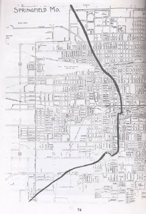
It describes the route of the Butterfield through Springfield this way:
“The Butterfield Overland Mail entered northwest Springfield via the Old Booneville Road. As with the Wire road, almost all traces of the old route have been obliterated.
“Crossing Kearney Street, a short distance west of North Fort Street, it continued to Commercial Street and Broadway Avenue. From there it traveled south and east, and entered Boonville avenue (then Booneville road) at Nichols Street, present location of the Greene County Court House. It then proceeded south on Boonville to the Public Square and a scheduled stop at the Nicholas Smith Hotel, on the northeast corner of Booneville and the Public Square.
The coaches then traveled two blocks west to Cambell, where they turned south passing Maple Park Cemetery on the east side of Cambell Avenue. A semi-circle in the route led by Fassnight Park on the north side of the road. From this point the Butterfield Overland Mail continued southwest crossing Sunshine Street a short distance east of Scenic Street. The road then cut
across property now owned by the present United States Medical Center and left Springfield on its way across Greene and other counties.”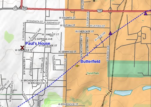
One of the most interesting discoveries on this map was just how close the original Butterfield Trail came to Paul’s house. We knew it came through Springfield but until this trip we didn’t really know exactly where.

Really, how amazing is that? It is less than a mile.
Of course, we didn’t know this at the time. We were just interested in following the Butterfield Trail to see where it would take us. It was our good fortune on this night to be right back in Springfield. We indulged in another comfy night at Paul’s and celebrated with showers and a Sushi delivery. We enjoyed our food as we planned for the next day of our trip.
The first day really couldn’t have been better. We had a good shake down of our equipment and we got a real sense of how often the stations were placed and how much fun it would be to look for them. The Stage had averaged 120 miles a day and completed the 2,800 mile trip in 24 days. Paul and I had covered only 10 stations and 160 miles in about 7 hours. The Stations averaging about 13 miles apart. Of course, our first day required that we back track and cover double the miles. Still it is hard to imagine traveling by stagecoach from Tipton to Springfield
 For young John Jr., (shown on the right) pushing his horses as hard as he could, it was nearly 21 hours before they pulled into Springfield at 3:15 pm on Friday. This was the fastest trip ever made from Tipton to Springfield and put the Overland Mail nearly 17 hours ahead of schedule through very uncertain territory. An auspicious beginning for sure. Not one to rest on their laurels, the stage, though well received, departed just 45 minutes later after a change of coaches, some additional passengers and of course, taking aboard more mail. Paul and I on the other hand could look forward to a good night’s sleep.
posted by Don and Paul Matt at 7:05 AM
4 comments
![]()


